Robert Stuart Trail 1812 — 1813


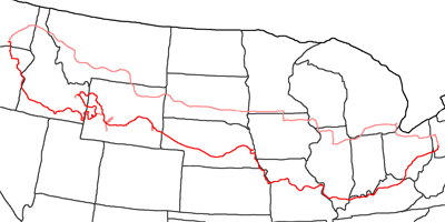
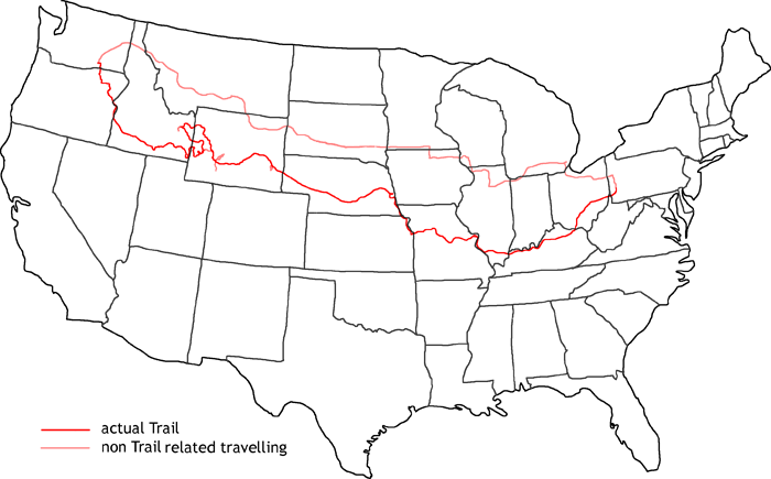
Map of Robert Stuart Trail
In 2007 I follow the trail of Robert Stuart, who was like Hunt sent out by John Jacob Astor to find a suitable trade route over the Rockies. The start was Astoria in nowadays Oregon.
But before the trail starts, I get my 88 Chevy S10 BDS Lift Kit installed. As this trail runs from west to east, I visit first my friends Matt & Jean in Detroit and Sherry and her family in Prairie Du Chien. Then I drive on the Interstates up to Richland in Washington. Originally, the Robert Stuart Trail starts in Astoria. But due to lack of time I have to skip the leg along the Columbia River. I followed this stretch already in my last years Wilson Price Hunt Trail to the west.
From Richland I drive on south to the mouth of the Walla Walla River. Crossing the hills south of the river I reach Pendleton and follow McKay Creek to Whitman National Forest. Like last year, Private Property forces me to take a detour south to the Blue Mountains until I reach at the Grande Ronde River the main trail again.
The last part of the mountain ridge to La Grande I have to cross on Interstate 84. From La Grande I travel via Union to North Powder and further on to Baker City. Along I–84 and a couple of small backroads I reach the Snake River and arrive at Ontario following Spur 95. Along the Snake I reach American Falls and the Portneuf River.
There I leave Hunt’s route from last year and follow Stuart’s trail along the Portneuf River to McCammon and the branch of Highway 30 to the east. Passing Lava Hot Springs, I arrive at Alexandra and further on to the southeast I reach Montpelier. This is the area of the ‘Big Hills’, where later the Oregon Trail will run through. If Stuart would have marched on to the southeast, he would have run straight into South Pass. But afraid of the Indians and not exactly knowing where he was, he decided to go up north, crossing Gannett Hills and Sheep Pass, reaching the valley of Grey River. He followed the river up north to the Snake River and along the Snake to Heise.
There he reached Hunt’s old trail over Teton Pass, which he followed. Along Hoback River and further on to the southeast, he reached South Pass via Pinedale. He crossed the Great Divide Basin to the east and reached through Muddy Gap the Sweetwater River. He followed the river to North Platte and searched for a winter quarter. Because of the Indians, he had to give up his first camp at North Platte and went on upstream to nowadays Torrington close to the state line of Nebraska.
In March 1813, the expedition started the last leg. They went along the North Platte River to the Missouri River and further on to St. Louis. There, Stuart changed from canoe to horse and rode along the Ohio River to Pittsburgh and further on to New York.
For the first time of my trails, the trail ends directly in Pittsburgh for me.
- Day 1: August 12th, 2007 Munich — Pittsburgh
- Day 2: August 13th, 2007 Pittsburgh (Mine)
- Day 3: August 14th, 2007 Pittsburgh — Stewartsville
- Day 4: August 15th, 2007 Stewartsville (OK4WD) — West Chester
- Day 5: August 16th, 2007 West Chester — Stewartsville (OK4WD)
- Day 6: August 17th, 2007 Stewartsville (OK4WD)
- Day 7: August 18th, 2007 Stewartsville — Pittsburgh
- Day 8: August 19th, 2007 Pittsburgh — Detroit
- Day 9: August 20th, 2007 Detroit — Prairie Du Chien
- Day 10: August 21st, 2007 Prairie Du Chien — Mitchell
- Day 11: August 22nd, 2007 Mitchell — Rapid City
- Day 12: August 23rd, 2007 Rapid City — Bozeman
- Day 13: August 24th, 2007 Bozeman — Richland
- Day 14: August 25th, 2007 Richland — La Grande
- Day 15: August 26th, 2007 La Grande — Ontario
- Day 16: August 27th, 2007 Ontario — Twin Falls
- Day 17: August 28th, 2007 Twin Falls — Pocatello
- Day 18: August 29th, 2007 Pocatello
- Day 19: August 30th, 2007 Pocatello — Montpelier
- Day 20: August 31th, 2007 Montpelier — Afton
- Day 21: September 1st, 2007 Afton
- Day 22: September 2nd, 2007 Afton — Pinedale
- Day 23: September 3rd, 2007 Pinedale — Idaho Falls
- Day 24: September 4th, 2007 Idaho Falls — Pinedale
- Day 25: September 5th, 2007 Pinedale — Rock Springs
- Day 26: September 6th, 2007 Rock Springs — Lander
- Day 27: September 7th, 2007 Lander — Rawlins
- Day 28: September 8th, 2007 Rawlins — Casper
- Day 29: September 9th, 2007 Casper — Wheatland
- Day 30: September 10th, 2007 Wheatland — Scottsbluff
- Day 31: September 11th, 2007 Scottsbluff — North Platte
- Day 32: September 12th, 2007 North Platte — Grand Island
- Day 33: September 13th, 2007 Grand Island — Omaha
- Day 34: September 14th, 2007 Omaha — Kansas City
- Day 35: September 15th, 2007 Kansas City — St. Charles
- Day 36: September 16th, 2007 St. Charles — Henderson
- Day 37: September 17th, 2007 Henderson — Maysville
- Day 38: September 18th, 2007 Maysville — Pittsburgh
- Day 39: September 19th, 2007 Pittsburgh (Chevrolet Dealer)
- Day 40: September 20th, 2007 Pittsburgh (Mine)
- Day 41: September 21st, 2007 Pittsburgh — Munich
